


As the Japan Alps are among the better ventilated mountains on the planet, local alpinists have devised a special stance for riding out knock-down gusts. Here Ito-san from Yokohama shows how it’s done – legs akimbo, body weight driving the ice-axe handle vertically into the snow, so as to make a tripod. Practise often: it might save your life one day.

The surveyors
How the map-makers led the way for Japan's modern-day mountaineers
The first modern ascent of Mae-Hodaka was all but fatal for its instigators. After topping out on the 3,090-metre peak and marking the highest point with a wooden peg, the two men started their descent. At that moment, the Army man slipped. His guide looked on, aghast, as the survey officer’s body bounced and tumbled, limbs flailing like a rag-doll’s, down twenty, forty, sixty feet of granite slabs before slamming onto a ledge.
As quickly as he dared, the guide picked his way down the treacherous gully and edged across to the inert figure, hardly daring to hope. Amazed, he heard a groan; the Army man was still alive. Then, half-supporting and half-carrying his bloodied client, the guide brought him down to Kami-kōchi, where he kept a lodge. The legendary Kamijō Kamonji had pulled off the Meiji era's first high-mountain rescue.
As for the "damaged surveyor", he was discovered a few weeks later by Walter Weston, recuperating from his wounds at a nearby hot spring. Undismayed, the mountaineering missionary continued with his own plans to engage Kamonji and repeat the Mae-Hodaka ascent. The guide and the Englishman made an efficient team, as Weston records in his Mountaineering and Exploration in the Japanese Alps:-
"Before 1.30 we were on the highest pinnacle. Driven into a crack in the rock I found a small stake, which marked the visit of the War Office surveyor some weeks before. As I looked down the rocks, where Kamonji pointed out the line of his fall, it seemed incredible the man could have survived."
Tate Kiyohiko (1849-1927) was a tough customer. Not only did he survive his fall but, by the following year, he was fit enough to climb two more 3,000-metre summits. Together with the three mountains he'd already scouted, these tops would host the five "primary triangulation points" for the War Office's mapping of the Northern Alps. His name appears neither in Weston's book nor in Kojima Usui's account of the same accident. Yet he was one of the true pioneers of the Northern Japan Alps, at least in modern times.
Indeed, he was a pioneer among pioneers. It was no accident that Tate took responsibility for siting the all-important primary markers. For his career went back to the very outset of modern map-making in Japan. At the age of 22 or so, in July 1871, he'd joined the survey department of the new Ministry of Public Works. In 1874, these civilian map-makers were brought into the Home Ministry's Geographical Department. A few years later, they were out surveying among the highest mountains of Honshū, as Japan’s most famous mountain book records:
Occupying the position that it does, Akaishi has a name that resonates through the centuries. A party from the Home Ministry's geographical bureau reached the summit in 1879 and erected a survey marker there. A permanent triangulation point was installed a decade later, just a year after Japan's Land Survey Department was established. These efforts laid the groundwork for the 1:50,000-scale maps that are so indispensable to our mountaineering ventures today. (Nihon Hyakumeizan, Akaishi-dake)
By this time, the Army had started its own map-making unit, which was folded into the new Staff Department in 1872. A French military mission helped it get up to speed on the latest surveying techniques. In 1888, the Army's General Staff unit, as it was now known, took over responsibility for the national survey and, with it, the map-makers of the Home Ministry too. The merged unit became the “Land Survey Department” mentioned in the quotation from Nihon Hyakumeizan above.
Five years later, the Army surveyors were filling in the remaining blanks on the new maps of Honshū. And Tate was on hand to lead the way into the high mountains. In 1893, he set the first primary triangulation point for this part of the survey by climbing Ontake, the isolated volcano at the southern end of the Hida mountains (the Japan Alps hadn't yet been invented, of course). In the same summer, he reached the summits of Shirouma and Mae-Hodaka, the scene of his near-demise.
In 1894, the veteran surveyor – now in his mid-forties – placed markers on the volcanic peaks of Norikura and Tateyama, the final primary triangulation points for the Northern Japan Alps. In fact, each peak in the survey had to be climbed three times - first to identify a suitable spot for the triangulation point, then to build up a high wooden marker, and finally to take the survey measurements themselves. Tate's role was to find the right spots; the work of building the survey markers and taking the theodolite measurements was left to colleagues.
Every step in this process was recorded in a so-called "Ten-no-ki", a record of each survey marker's position, the costs and efforts involved in setting it up, and the survey results. As these dossiers make for dry-as-dust reading, it is fortunate for posterity that Tate supplemented them with some lively and presumably unofficial sketches. One of them (right) shows him tobogganing down the Great Snow Valley of Shirouma, seated on a torn-off branch of creeping pine that a porter is hauling along.
After Tate's last season in Hida mountains, his younger colleagues took on the work of setting up the secondary triangulation points. In 1902, they visited Yakushi-dake, Noguchi-goro, Kasa-ga-dake, Kashimayari, Sugoroku and finally Yari-ga-dake - narrowly beating the young banker and writer Kojima Usui to the top of that spire-shaped summit.
After a pause enforced by the Russo-Japanese war, the tertiary triangulation points were set up and surveyed in 1906 and 1907. During those seasons, the surveyors fanned out over the (soon-to-be) Northern Alps to Karasawa-dake, Minami-dake, Nishi-Hodaka, Suishō, Washiba, Otenshō, Aka-ushi, Mitsu-dake, Mitsumata-renge, Kurobe-goro, Nukedo, Tsurugi, Hari-no-ki, Jii-ga-take, and the “other” Yari-ga-take (鑓ヶ岳).
The ascent of Tsurugi, in July 1907 is, of course, the one dramatised in Tsurugidake – Ten no ki. This recent film makes great play of a supposed race to the summit between Shibasaki Yoshitarō, the Army surveyor (right), and the slightly effete gentlemen amateurs of the new Japanese Alpine Club or Sangaku-kai. But it’s doubtful whether any such contest took place; history relates that the leading lights of the Sangaku-kai were exploring the Southern Japan Alps in the relevant summer.
In reality, the surveyors had thoroughly explored the Hida mountains well before Kojima Usui and his friends founded their alpine club, in October 1905. But it would take some time for the Army to translate its survey results into actual maps. As a kind of consolation, therefore, the alpinists were left about a decade to discover the mountains for themselves. Then, in the mid-teens of the century, the Army General Staff started to bring out its detailed map series for the Northern Alps, dispelling some of their mystery in the process.
In later years, the Sangaku-kai’s old guard looked fondly back on this map-free “golden age of mountain exploration” (the phrase was invented or borrowed by Kojima himself). And some of this sepia-tinged nostalgia filtered down to the club’s younger members – even to Fukada Kyūya, who joined in June 1935, two decades after the golden age ended. This helps to explain the elegiac note sounded by such passages in Nihon Hyakumeizan as this one:-
The first mountaineer to pass this way was Shimura Urei in the summer of 1907, approaching from Eboshi. As he stood on the summit, he wrote, "I saw a small pond below and to the south, for all the world like an eruption crater … this crater on Washiba is probably a surprise for the world." In that pioneering era, such unexpected discoveries were not uncommon in the Northern Alps. Today, mountaineering is much more convenient but it has lost this element of surprise and wonder.
 For their part, the surveyors had little time for nostalgia. The Army kept them ceaselessly on the move. As far as the General Staff were concerned, the Northern Alps were just a skirmish in their northwards drive to map every square metre of the Japanese islands. And when that campaign ended, there was a growing empire overseas that had to be accurately reduced to scale.
In this rolling advance, Shibasaki Yoshitarō was one of the foot-soldiers. And perhaps his story can stand for all of them. The year after his Tsurugi ascent he completed a survey in nearby Niigata prefecture. From 1909 to 1913, he was mapping first in Tohoku and then in Hokkaidō – where he also wrote a paper on Ainu legends. In 1914-15, he was back in central Honshū and found time to write up the first part of a monograph on the medieval battlefield site of Sekigahara.
Then he spent another two years in Hokkaidō, surveying the Ishikari and Kitami regions, as well as the northern island of Etorofu. In 1918-19, he accompanied the Army’s foray into Siberia (for what purpose remains obscure: possibly he was collating captured Russian maps), returning to Hokkaidō thereafter. Then the Army sent him to Taiwan, where he spent four years working on the secondary triangulation of the island’s central and northern districts.
In the end, the incessant expeditioning may have been too much for him. In 1930, Shibasaki suffered a stroke and, although he recovered enough to go back to work, he retired from government service in 1933. He died in January 1938, aged 64. Perhaps in those last years, there was a moment or two for recollection. Did Shibasaki look back then to Tsurugi as the high point among all his "Ten no ki", in that cool alpine summer, decades ago, when rugged Chojirō and Kinsaku found a way for him up the most difficult mountain in all Japan?
References
Seto Masahiro, Survey mountaineering in late Meiji times, Japan Journal of Survey, July 2008
Seto Masahiro, Shibasaki Yoshitarō: what happened then ( Part 1), Japan Journal of Survey, April 2009
Seto Masahiro, Shibasaki Yoshitarō: what happened then (Part 2), Japan Journal of Survey, May 2009
 Yamada Akira, The day Shibasaki Yoshitarō climbed Tsurugi, Japan Journal of Survey, August 2008
Hakoiwa Eiichi, The role of the Army General Staff in surveying, Japan Journal of Survey, July 2008
Seto Masahiro, Kojima Usui, the multi-talented alpinist, Japan Journal of Survey, September 2008
Seto Masahiro, Uji Chojirō, the guide who supported Shibasaki’s survey party, Japan Journal of Survey, September 2008
The first modern ascent of Mae-Hodaka was all but fatal for its instigators. After topping out on the 3,090-metre peak and marking the highest point with a wooden peg, the two men started their descent. At that moment, the Army man slipped. His guide looked on, aghast, as the survey officer’s body bounced and tumbled, limbs flailing like a rag-doll’s, down twenty, forty, sixty feet of granite slabs before slamming onto a ledge.
 |
| The survey marker on Tsurugi in 1909 |
As quickly as he dared, the guide picked his way down the treacherous gully and edged across to the inert figure, hardly daring to hope. Amazed, he heard a groan; the Army man was still alive. Then, half-supporting and half-carrying his bloodied client, the guide brought him down to Kami-kōchi, where he kept a lodge. The legendary Kamijō Kamonji had pulled off the Meiji era's first high-mountain rescue.
 |
| Oku-Hodaka seen from Mae-Hodaka |
"Before 1.30 we were on the highest pinnacle. Driven into a crack in the rock I found a small stake, which marked the visit of the War Office surveyor some weeks before. As I looked down the rocks, where Kamonji pointed out the line of his fall, it seemed incredible the man could have survived."
 |
| Tate Kiyohiko |
Indeed, he was a pioneer among pioneers. It was no accident that Tate took responsibility for siting the all-important primary markers. For his career went back to the very outset of modern map-making in Japan. At the age of 22 or so, in July 1871, he'd joined the survey department of the new Ministry of Public Works. In 1874, these civilian map-makers were brought into the Home Ministry's Geographical Department. A few years later, they were out surveying among the highest mountains of Honshū, as Japan’s most famous mountain book records:
Occupying the position that it does, Akaishi has a name that resonates through the centuries. A party from the Home Ministry's geographical bureau reached the summit in 1879 and erected a survey marker there. A permanent triangulation point was installed a decade later, just a year after Japan's Land Survey Department was established. These efforts laid the groundwork for the 1:50,000-scale maps that are so indispensable to our mountaineering ventures today. (Nihon Hyakumeizan, Akaishi-dake)
 |
| Army surveyors carry a 50-kg theodolite into the mountains. |
Five years later, the Army surveyors were filling in the remaining blanks on the new maps of Honshū. And Tate was on hand to lead the way into the high mountains. In 1893, he set the first primary triangulation point for this part of the survey by climbing Ontake, the isolated volcano at the southern end of the Hida mountains (the Japan Alps hadn't yet been invented, of course). In the same summer, he reached the summits of Shirouma and Mae-Hodaka, the scene of his near-demise.
 |
| The survey tower on Shirouma |
In 1894, the veteran surveyor – now in his mid-forties – placed markers on the volcanic peaks of Norikura and Tateyama, the final primary triangulation points for the Northern Japan Alps. In fact, each peak in the survey had to be climbed three times - first to identify a suitable spot for the triangulation point, then to build up a high wooden marker, and finally to take the survey measurements themselves. Tate's role was to find the right spots; the work of building the survey markers and taking the theodolite measurements was left to colleagues.
 |
| Surfing the Great Snow Valley |
After Tate's last season in Hida mountains, his younger colleagues took on the work of setting up the secondary triangulation points. In 1902, they visited Yakushi-dake, Noguchi-goro, Kasa-ga-dake, Kashimayari, Sugoroku and finally Yari-ga-dake - narrowly beating the young banker and writer Kojima Usui to the top of that spire-shaped summit.
After a pause enforced by the Russo-Japanese war, the tertiary triangulation points were set up and surveyed in 1906 and 1907. During those seasons, the surveyors fanned out over the (soon-to-be) Northern Alps to Karasawa-dake, Minami-dake, Nishi-Hodaka, Suishō, Washiba, Otenshō, Aka-ushi, Mitsu-dake, Mitsumata-renge, Kurobe-goro, Nukedo, Tsurugi, Hari-no-ki, Jii-ga-take, and the “other” Yari-ga-take (鑓ヶ岳).
 |
| Shibasaki Yoshitaro |
In reality, the surveyors had thoroughly explored the Hida mountains well before Kojima Usui and his friends founded their alpine club, in October 1905. But it would take some time for the Army to translate its survey results into actual maps. As a kind of consolation, therefore, the alpinists were left about a decade to discover the mountains for themselves. Then, in the mid-teens of the century, the Army General Staff started to bring out its detailed map series for the Northern Alps, dispelling some of their mystery in the process.
 |
| Surveyors at work: a sketch by Tate Kiyohiko |
The first mountaineer to pass this way was Shimura Urei in the summer of 1907, approaching from Eboshi. As he stood on the summit, he wrote, "I saw a small pond below and to the south, for all the world like an eruption crater … this crater on Washiba is probably a surprise for the world." In that pioneering era, such unexpected discoveries were not uncommon in the Northern Alps. Today, mountaineering is much more convenient but it has lost this element of surprise and wonder.
 For their part, the surveyors had little time for nostalgia. The Army kept them ceaselessly on the move. As far as the General Staff were concerned, the Northern Alps were just a skirmish in their northwards drive to map every square metre of the Japanese islands. And when that campaign ended, there was a growing empire overseas that had to be accurately reduced to scale.
In this rolling advance, Shibasaki Yoshitarō was one of the foot-soldiers. And perhaps his story can stand for all of them. The year after his Tsurugi ascent he completed a survey in nearby Niigata prefecture. From 1909 to 1913, he was mapping first in Tohoku and then in Hokkaidō – where he also wrote a paper on Ainu legends. In 1914-15, he was back in central Honshū and found time to write up the first part of a monograph on the medieval battlefield site of Sekigahara.
Then he spent another two years in Hokkaidō, surveying the Ishikari and Kitami regions, as well as the northern island of Etorofu. In 1918-19, he accompanied the Army’s foray into Siberia (for what purpose remains obscure: possibly he was collating captured Russian maps), returning to Hokkaidō thereafter. Then the Army sent him to Taiwan, where he spent four years working on the secondary triangulation of the island’s central and northern districts.
 |
| Meiji-era mountain guides |
References
Seto Masahiro, Survey mountaineering in late Meiji times, Japan Journal of Survey, July 2008
Seto Masahiro, Shibasaki Yoshitarō: what happened then ( Part 1), Japan Journal of Survey, April 2009
Seto Masahiro, Shibasaki Yoshitarō: what happened then (Part 2), Japan Journal of Survey, May 2009
 Yamada Akira, The day Shibasaki Yoshitarō climbed Tsurugi, Japan Journal of Survey, August 2008
Hakoiwa Eiichi, The role of the Army General Staff in surveying, Japan Journal of Survey, July 2008
Seto Masahiro, Kojima Usui, the multi-talented alpinist, Japan Journal of Survey, September 2008
Seto Masahiro, Uji Chojirō, the guide who supported Shibasaki’s survey party, Japan Journal of Survey, September 2008
Images and ink (14)
Image: Azuma-Kofuji: photo posted on flickr by Parmanand Sharma (many thanks, Parmanand!)
Ink: On Azuma-yama, from Nihon Hyakumeizan (One Hundred Mountains of Japan) by Fukada Kyūya (1964):
To call it simply "Azuma-yama" could be misleading. For few mountains sprawl with as much abandon as this one. As the massif sits astride the border between Fukushima and Yamagata prefectures, it is much visited, but most people confine their attention to a mere fraction of its entirety.
No one peak rises above the others to define this massif. At the same time, ten of those summits exceed 1,900 metres, a rare height for Tōhoku. Yet all are squat in shape and lacking in distinctive features, making it hard to tell them apart from a distance.
True to its name, one of these peaks, Azuma-Kofuji, does show some character. At a mere 1,700 metres, though, this miniature Fuji can hardly serve as the massif's representative summit. Nor does the way in which the names of East Azuma, Middle Azuma, and West Azuma are scattered about do much to distinguish the topography. Holding their own against their peers, Issaikyō-yama, and the East and West Daitens are peaks in much the same genre ....

Ink: On Azuma-yama, from Nihon Hyakumeizan (One Hundred Mountains of Japan) by Fukada Kyūya (1964):
To call it simply "Azuma-yama" could be misleading. For few mountains sprawl with as much abandon as this one. As the massif sits astride the border between Fukushima and Yamagata prefectures, it is much visited, but most people confine their attention to a mere fraction of its entirety.
No one peak rises above the others to define this massif. At the same time, ten of those summits exceed 1,900 metres, a rare height for Tōhoku. Yet all are squat in shape and lacking in distinctive features, making it hard to tell them apart from a distance.
True to its name, one of these peaks, Azuma-Kofuji, does show some character. At a mere 1,700 metres, though, this miniature Fuji can hardly serve as the massif's representative summit. Nor does the way in which the names of East Azuma, Middle Azuma, and West Azuma are scattered about do much to distinguish the topography. Holding their own against their peers, Issaikyō-yama, and the East and West Daitens are peaks in much the same genre ....
The inner world of Mt Asama
Investigating the crater’s secrets with some help from the academicians
Our luck was out. We’d left Tokyo in the early hours, hiked over the old volcano’s wall and now, around noon, we stood atop Mt Asama’s curving summit ridge. Sulphurous steam roiled at our feet before heaving its way up into the sky; today, there would be no gazing, spellbound, into the nether world of the crater floor, corralled by its ring of scorched and blasted cliffs.

What is it about Mt Asama? As a climb, it has little merit. Yet that crater has pulling power. It was Asama that Kojima Usui, the founder of the Japanese Alpine Club, chose for his first excursion over 2,000 metres. That was in 1899. A few years later, the adventure photographer Herbert Ponting brought along a step-ladder so that he could peer just a mite further into the crater. And, as we have seen, he nearly paid for his temerity with his life.
Nor can the savants keep away. Scientific observations at Asama started in 1910, seven years after Ponting’s visit, “motivated by eruptions and a seismic swarm”. In fact, this was one of the earliest seismic observations made of an active volcano. Since our own visit in the mid-1990s, a quiet period, Asama has hotted up. In 2009, a light ash-fall drifted as far as Tokyo. A few months later, cameras on the crater rim caught the opening of a new vent in the crater floor.

For the academicians, this activity has been an incitement. Starting with “only six seismometers” just before the turn of the century, they’ve festooned the mountain and surrounding areas with 30 seismometers, 15 GPS sites, 10 tiltmeters, nine microphones, and two cosmic muon detectors.
The kit has helped the geologists put together a clearer picture of Asama’s underworld. They can now tell you, at least tentatively, what you might find if you ventured down into the crater – that is, provided you could stand the noxious gases and the 200°C heat there – and if, like Professor Lidenbrock in Journey to the Centre of the Earth, you then decided to investigate that mysterious vent in the crater floor.

Jules Verne would certainly get a run for his money from this journey. Once you’d dug or drilled a way through the congealed lava that plugs the vent, you’d find yourself in a “conduit” about fifty metres across, twisting downwards into the darkness. You’d need a long abseil rope or ladder: the shaft drops more or less vertically for three kilometres – the height of the mountain plus a further kilometre into the depths of Japan’s basement rocks.
At last, the vertical shaft debouches into the ceiling of a vast chamber. If the view were not blocked by a sluggish volume of semi-molten rock, you’d see it opening out into a vast cavern – somewhat like one of those Cyclopean storm-sewers in Tokyo, yet hundreds of times larger, and rather higher than it is wide.
 Now you get the picture – the upwelling lava has forced the country rocks aside for several kilometres. You follow this dyke – a giant underground ravine – for several kilometres, more or less horizontally.
It takes you westwards and slightly north of Asama’s summit, out under the old Kurofu crater rim. Strange, you ponder: wherever the lava that feeds Asama’s eruptions comes from, it seems not to rise from directly beneath the mountain.
Five or so kilometres northwest of Asama’s summit, the rugged walls of the dyke start to close in. And there you start to sense far below you – another few kilometres down – a steady, intense reverberation of dull-red heat.
So this is where the lava comes from – a vast magma chamber, offset to Asama’s west, and doming out some four or five kilometres below sea level. From there, the molten slurries force their way up periodically into the dyke, and thence to the surface. Well, we’re not going down any further – it’s hot as hell here in the dyke, so you’ll have to imagine conditions in the magma chamber for yourself…

Up on the summit of Asama, at 2,568 metres above sea level, the summer breeze blew cool. Clouds had started to drift in too, mingling as they lofted over the rim with the steam from the crater. It was time to go. We found the path and followed its slant across the black-ribbed slope.
At the foot of the cinder cone, we met a troupe of Thai girls, in sandals and T-shirts, on their day off from some nearby bar or factory. We could hear their laughter for a long time, floating down from the summit, while we climbed the J-Band back towards the outer world. Perhaps they’d been rewarded with a better view.
Reference
Y Aoki, M Takeo, T Ohminato, Y Nagaoka and K Nishida: Magma pathway and its structural controls of Asama Volcano, Japan - image of vent and chart above from this paper.
And see Tsubakuro's blog for a more recent visit to Mt Asama - complete with a spectacular image of the new "live" vent.
Our luck was out. We’d left Tokyo in the early hours, hiked over the old volcano’s wall and now, around noon, we stood atop Mt Asama’s curving summit ridge. Sulphurous steam roiled at our feet before heaving its way up into the sky; today, there would be no gazing, spellbound, into the nether world of the crater floor, corralled by its ring of scorched and blasted cliffs.

What is it about Mt Asama? As a climb, it has little merit. Yet that crater has pulling power. It was Asama that Kojima Usui, the founder of the Japanese Alpine Club, chose for his first excursion over 2,000 metres. That was in 1899. A few years later, the adventure photographer Herbert Ponting brought along a step-ladder so that he could peer just a mite further into the crater. And, as we have seen, he nearly paid for his temerity with his life.
Nor can the savants keep away. Scientific observations at Asama started in 1910, seven years after Ponting’s visit, “motivated by eruptions and a seismic swarm”. In fact, this was one of the earliest seismic observations made of an active volcano. Since our own visit in the mid-1990s, a quiet period, Asama has hotted up. In 2009, a light ash-fall drifted as far as Tokyo. A few months later, cameras on the crater rim caught the opening of a new vent in the crater floor.

For the academicians, this activity has been an incitement. Starting with “only six seismometers” just before the turn of the century, they’ve festooned the mountain and surrounding areas with 30 seismometers, 15 GPS sites, 10 tiltmeters, nine microphones, and two cosmic muon detectors.
The kit has helped the geologists put together a clearer picture of Asama’s underworld. They can now tell you, at least tentatively, what you might find if you ventured down into the crater – that is, provided you could stand the noxious gases and the 200°C heat there – and if, like Professor Lidenbrock in Journey to the Centre of the Earth, you then decided to investigate that mysterious vent in the crater floor.

Jules Verne would certainly get a run for his money from this journey. Once you’d dug or drilled a way through the congealed lava that plugs the vent, you’d find yourself in a “conduit” about fifty metres across, twisting downwards into the darkness. You’d need a long abseil rope or ladder: the shaft drops more or less vertically for three kilometres – the height of the mountain plus a further kilometre into the depths of Japan’s basement rocks.
At last, the vertical shaft debouches into the ceiling of a vast chamber. If the view were not blocked by a sluggish volume of semi-molten rock, you’d see it opening out into a vast cavern – somewhat like one of those Cyclopean storm-sewers in Tokyo, yet hundreds of times larger, and rather higher than it is wide.
 Now you get the picture – the upwelling lava has forced the country rocks aside for several kilometres. You follow this dyke – a giant underground ravine – for several kilometres, more or less horizontally.
It takes you westwards and slightly north of Asama’s summit, out under the old Kurofu crater rim. Strange, you ponder: wherever the lava that feeds Asama’s eruptions comes from, it seems not to rise from directly beneath the mountain.
Five or so kilometres northwest of Asama’s summit, the rugged walls of the dyke start to close in. And there you start to sense far below you – another few kilometres down – a steady, intense reverberation of dull-red heat.
So this is where the lava comes from – a vast magma chamber, offset to Asama’s west, and doming out some four or five kilometres below sea level. From there, the molten slurries force their way up periodically into the dyke, and thence to the surface. Well, we’re not going down any further – it’s hot as hell here in the dyke, so you’ll have to imagine conditions in the magma chamber for yourself…

Up on the summit of Asama, at 2,568 metres above sea level, the summer breeze blew cool. Clouds had started to drift in too, mingling as they lofted over the rim with the steam from the crater. It was time to go. We found the path and followed its slant across the black-ribbed slope.
At the foot of the cinder cone, we met a troupe of Thai girls, in sandals and T-shirts, on their day off from some nearby bar or factory. We could hear their laughter for a long time, floating down from the summit, while we climbed the J-Band back towards the outer world. Perhaps they’d been rewarded with a better view.
Reference
Y Aoki, M Takeo, T Ohminato, Y Nagaoka and K Nishida: Magma pathway and its structural controls of Asama Volcano, Japan - image of vent and chart above from this paper.
And see Tsubakuro's blog for a more recent visit to Mt Asama - complete with a spectacular image of the new "live" vent.
Fires of Tartarus
A close call for two foreign visitors on Mt Asama
What is it about Mt Asama? On a fine day in October 1903, while climbing the volcano's lower slopes, the two Englishmen had seen “a cyclopean pillar of writhing smoke and vapour pouring up into the vault of heaven”. This should have reinforced the warnings they'd already heard and dismissed. Yet still they pressed on – something drew them – until they stood on the very lip of the fuming crater.

SHOOTING THE VOLCANO IN OLD JAPAN -- Photographer and Coolie Living Dangerously, a photo by Okinawa Soba on Flickr.Or perhaps Asama's attractive powers weren't so mysterious. Herbert Ponting - the photographer who would later accompany Captain Scott on his last expedition - was in Japan to write a travel book and take pictures, the more spectacular the better. He'd already visited Aso-san in Kyushu, but that gigantic crater had proved disappointingly mild-mannered. So he had high hopes of Asama... Here Ponting takes up the story in his own words:
 We saw an immense pit, six hundred feet or more across, and almost perfectly round, with perpendicular walls towering up from the bottom, five hundred feet or so below. These walls were burnt, and scorched, and stained with fire to every colour of the spectrum, and from a myriad cracks and crannies sulphurous jets of steam hissed out, each contributing its quota to the filmy vapours that rose out of the abyss from the fires of Tartarus below. Through the thin steam the entire crater floor was visible. It was a huge solfatara, with numerous holes from which molten matter was spurting, and red-hot lava pools which now and then were licked by little tongues of flame.
The noise of the place was truly infernal. There is no other sound on earth that can be likened to the sticky, sputtering buzz of a volcano. It is fearful to listen to — this vibrating, throbbing, pulsating din of ceaseless, steady boiling. The thing seemed to be fermenting with suppressed rage, and one half expected that any moment it would burst open and loose the furies it could scarce restrain …
Whilst absorbed in the contemplation of these beautiful surroundings, and the wondrous red and purple colouring of an ancient broken crater on the mountain's western side, the time sped swiftly on, and it was not until 3 o'clock that we prepared to leave. Our coolies went on ahead, but Hurley and I stopped a few moments for a last look at the crater, from which we found it hard to tear ourselves away. As we stood on the brink of the diabolical abyss there was a crash like a thunder-clap, and the earth seemed to split before us as the bed of the crater parted asunder and burst upwards, throwing thousands of tons of rock against the walls. For a moment or two the noise was like the din of battle. Masses of rock were hurled against the cliffs and shivered to fragments with reports like exploding shells, and showers of stones, whistling past us, shot many hundreds of feet into the air.
 It all occurred so quickly that I cannot recall all my sensations, but remember thinking that my last moment had surely come. It seemed we must inevitably be struck by the falling stones. My first impulse was to seek safety in flight; but after running a few paces it occurred to me that the stones were just as likely to hit me running as standing still. Hurley had also started to run, but was evidently seized with the same conviction, for, without a word, he stopped too, and we both waited for our fate. Just then the smoke, which rose from the crater immediately after the explosion, swept in a great cloud above us, so that we could not see the flying stones, or form any idea where they were likely to fall. I shall not soon forget those moments, as we gazed upwards, with arms involuntarily held tightly over our heads for protection, waiting for the descending missiles to drop out of the smoke-cloud and annihilate us.
And then the stones came clattering down — sticking, with sharp thuds, deep into the ash. By good luck the main force of the explosion was directed slightly to the east, and on that side of the crater most of them fell. We were on the southern rim, and in our vicinity only a sprinkling dropped compared with the hail of rock that must have fallen a little farther off.
 No sooner, however, were we safely delivered from Scylla than the perils of Charybdis were upon us. The smoke that was belching from the crater's mouth now enveloped us, and in a moment we were choking and almost asphyxiated with the sulphurous fumes. It was impossible to breathe, as, with hands tightly pressed over our mouths and nostrils, we blindly ran through the smoke for air. Fortune again was with us. In less than twenty paces we emerged suddenly from the chaos into brilliant sunlight, and staggered well out into safety before we fell upon the ground, gasping and filling our lungs to their fullest extent with great draughts of sweet pure air. It was a happy thing for us that the strong breeze which was now blowing was coming from the south ; thus the smoke was blown away from our side across the crater. Had it been blowing from the north we should have been unable to escape from the suffocating fumes.
This column of smoke was a thing of most awesome beauty, and held us fairly spell-bound. It belched up into the air in great, black rolls, which were emitted with such force and quantity that they were pushed far back into the teeth of the wind, and several times we had to retire still farther off as they bellied out towards us. It rose to the heavens in immense, writhing convolutions, and from the centre of the mass huge billows of snow-white steam puffed out, and bulged against the smoke, seeming to fight with it for mastery. But as white and black rose higher and higher in turn they mingled with each other, and soared up to the skies in a gradually diffusing pillar of grey which was tilted northwards by the wind and borne off rapidly into the clouds above.
References
Herbert Ponting, In Lotus-Land Japan (1910)
Many thanks to Okinawa Soba for posting Ponting’s dramatic photo on flickr, whence it is linked here. And to Tom Bouquet, volcanologist and educator, for originally posting this photo on his own (alas, dormant) Japan volcano blog. I hope he won’t mind me duplicating his efforts.
What is it about Mt Asama? On a fine day in October 1903, while climbing the volcano's lower slopes, the two Englishmen had seen “a cyclopean pillar of writhing smoke and vapour pouring up into the vault of heaven”. This should have reinforced the warnings they'd already heard and dismissed. Yet still they pressed on – something drew them – until they stood on the very lip of the fuming crater.
SHOOTING THE VOLCANO IN OLD JAPAN -- Photographer and Coolie Living Dangerously, a photo by Okinawa Soba on Flickr.

The noise of the place was truly infernal. There is no other sound on earth that can be likened to the sticky, sputtering buzz of a volcano. It is fearful to listen to — this vibrating, throbbing, pulsating din of ceaseless, steady boiling. The thing seemed to be fermenting with suppressed rage, and one half expected that any moment it would burst open and loose the furies it could scarce restrain …
Whilst absorbed in the contemplation of these beautiful surroundings, and the wondrous red and purple colouring of an ancient broken crater on the mountain's western side, the time sped swiftly on, and it was not until 3 o'clock that we prepared to leave. Our coolies went on ahead, but Hurley and I stopped a few moments for a last look at the crater, from which we found it hard to tear ourselves away. As we stood on the brink of the diabolical abyss there was a crash like a thunder-clap, and the earth seemed to split before us as the bed of the crater parted asunder and burst upwards, throwing thousands of tons of rock against the walls. For a moment or two the noise was like the din of battle. Masses of rock were hurled against the cliffs and shivered to fragments with reports like exploding shells, and showers of stones, whistling past us, shot many hundreds of feet into the air.

And then the stones came clattering down — sticking, with sharp thuds, deep into the ash. By good luck the main force of the explosion was directed slightly to the east, and on that side of the crater most of them fell. We were on the southern rim, and in our vicinity only a sprinkling dropped compared with the hail of rock that must have fallen a little farther off.
 No sooner, however, were we safely delivered from Scylla than the perils of Charybdis were upon us. The smoke that was belching from the crater's mouth now enveloped us, and in a moment we were choking and almost asphyxiated with the sulphurous fumes. It was impossible to breathe, as, with hands tightly pressed over our mouths and nostrils, we blindly ran through the smoke for air. Fortune again was with us. In less than twenty paces we emerged suddenly from the chaos into brilliant sunlight, and staggered well out into safety before we fell upon the ground, gasping and filling our lungs to their fullest extent with great draughts of sweet pure air. It was a happy thing for us that the strong breeze which was now blowing was coming from the south ; thus the smoke was blown away from our side across the crater. Had it been blowing from the north we should have been unable to escape from the suffocating fumes.
This column of smoke was a thing of most awesome beauty, and held us fairly spell-bound. It belched up into the air in great, black rolls, which were emitted with such force and quantity that they were pushed far back into the teeth of the wind, and several times we had to retire still farther off as they bellied out towards us. It rose to the heavens in immense, writhing convolutions, and from the centre of the mass huge billows of snow-white steam puffed out, and bulged against the smoke, seeming to fight with it for mastery. But as white and black rose higher and higher in turn they mingled with each other, and soared up to the skies in a gradually diffusing pillar of grey which was tilted northwards by the wind and borne off rapidly into the clouds above.
References
Herbert Ponting, In Lotus-Land Japan (1910)
Many thanks to Okinawa Soba for posting Ponting’s dramatic photo on flickr, whence it is linked here. And to Tom Bouquet, volcanologist and educator, for originally posting this photo on his own (alas, dormant) Japan volcano blog. I hope he won’t mind me duplicating his efforts.
The origins of alpinism (3)
How an association of young naturalists helped Kojima Usui get Japan’s first alpine club off the ground
By early 1905, the banker and journalist Kojima Usui had gathered round him all six of the friends who would help him found Japan’s and, indeed, Asia’s first alpine club. Of the club itself, however, there was still no sign. On March 25, Kojima was gently reminded of this fact by none other than Walter Weston, the mountaineering missionary.
 Four days before returning to England, at the end of his second stay in Japan, Weston invited his friends to a farewell party (above) at the Oriental Palace Hotel in Yokohama. Among the guests were Kojima himself, Okano Kinjirō, a Standard Oil man and Kojima’s companion on the ascent of Yari-ga-take in 1902, and the two young naturalists, Takeda Hisayoshi and Takano Takazō.
 It was Weston who had introduced Kojima to the idea of an alpine club at their first meeting in Yokohama, back in 1903. Now, at the farewell party, he presented Kojima with his copy of Ludwig Schröter’s Taschenflora des Alpen-Wanderers – which he’d recently brought back from an expedition to the Southern Alps. He also asked about progress with the alpine club; when it was founded, he’d like to sign up.
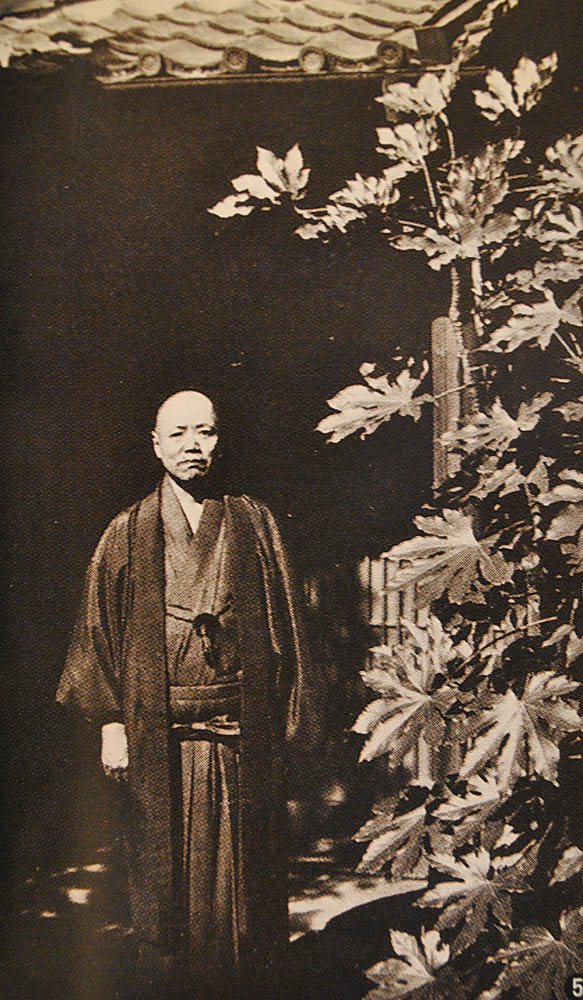
Weston’s hint seems to have galvanised Kojima and his colleagues. During the summer of 1905, hundreds of letters criss-crossed the city and scores of meetings took place. A particularly important one involved Takatō Shoku (right), a wealthy landowner from Niigata, who offered to cover the proposed club’s financial losses, if any, up to one thousand yen every year for ten years.
 The club now had a bankroller; it remained to devise a structure. For this, Kojima looked to Takeda Hisayoshi and his cohort of young amateur botanists and beetle fans. Back in 1901, the year Takeda graduated from the Tokyo Dai-Ichi Middle School (equivalent to today’s high school), he had helped to found a club of his own, the Japan Natural History Society (日本博物学同志), complete with its own journal.
On October 14, 1905, twelve of the natural historians convened for the Society’s thirtieth regular meeting. Takano Takazō took the chair, reporting on a recent plant-hunting foray to Tō-no-dake in the Tanzawa range. After the meeting, Takeda, Takano and two more of the naturalists met with Kojima, Takatō, and Jō Kazuma, a lawyer, to agree the details of the new alpine club.
In November, the newsletter of the Japan Natural History Society announced that an “Alpine Club” (山岳会) would be established as a “sub-section” (支会) of the Society “with the aim of pursuing all manner of research on mountains or connected with mountains”. As for Takano’s write-up of his Tō-no-dake trip, this would appear in the forthcoming first number of Sangaku, as the new sub-section’s journal would be known.
Meanwhile, Kojima was assiduously placing notices about the Sangaku-kai in Bunkō, Shinchō, Shinsei, Myōjō and other magazines likely to be read by the young Tokyo intelligentsia. And with success: membership of the alpine sub-section quickly overtook that of the parent Natural History Society. In fact, four hundred new members would join in the first year.
If the Sangaku-kai could so quickly take root as an independent club, why did Kojima choose to start it as an offshoot of the Natural History Society? One suggestion is that Kojima feared that, without the respectability conferred by Takeda’s naturalists, they would fail to attract the calibre of members he was looking for.
If such were Kojima's concerns, he must have been swiftly reassured. Distinguished men of letters – or men of letters who would shortly become distinguished – flocked to join. The club's 67th member was Yanagita Kunio, later to be acknowledged as the father of Japanese ethnography, who signed up in April 1906. Shimazaki Tōson joined too, and so did Tayama Katai - whose last novel, appropriately for an alpine club man, would be entitled Zansetsu (Lingering snow).
The new club appealed to scientists too. Yamasaki Naomasa, protagonist of Japan’s ancient glaciers, was there. So were Tanaka Akamaro, the first to study lacustrine sediments in Japan, and Jinbo Kotora, who researched both Hokkaidō's geology and the language of its native people, and there were many more besides.
Early editions of Sangaku amply reflect the interests of these scholar-mountaineers. And often, the resulting articles make for leaden reading. Yet this was a small price to pay for respectability. Alpinism had arrived in Japan. And, from the outset, it was a recreation fit for scholars and gentlemen.
References
Article by Kondo Nobuyuki on the JAC website about the club's origins:
近藤信行, 日本山岳会草創のころ
Chronology of Takeda Hisayoshi's life and career
Previous posts in this series
Shiga Shigetaka: the great instigator
How Kojima Usui climbed Yari-ga-take
Towards a Japanese Alpine Club
By early 1905, the banker and journalist Kojima Usui had gathered round him all six of the friends who would help him found Japan’s and, indeed, Asia’s first alpine club. Of the club itself, however, there was still no sign. On March 25, Kojima was gently reminded of this fact by none other than Walter Weston, the mountaineering missionary.
 Four days before returning to England, at the end of his second stay in Japan, Weston invited his friends to a farewell party (above) at the Oriental Palace Hotel in Yokohama. Among the guests were Kojima himself, Okano Kinjirō, a Standard Oil man and Kojima’s companion on the ascent of Yari-ga-take in 1902, and the two young naturalists, Takeda Hisayoshi and Takano Takazō.
 It was Weston who had introduced Kojima to the idea of an alpine club at their first meeting in Yokohama, back in 1903. Now, at the farewell party, he presented Kojima with his copy of Ludwig Schröter’s Taschenflora des Alpen-Wanderers – which he’d recently brought back from an expedition to the Southern Alps. He also asked about progress with the alpine club; when it was founded, he’d like to sign up.
Weston’s hint seems to have galvanised Kojima and his colleagues. During the summer of 1905, hundreds of letters criss-crossed the city and scores of meetings took place. A particularly important one involved Takatō Shoku (right), a wealthy landowner from Niigata, who offered to cover the proposed club’s financial losses, if any, up to one thousand yen every year for ten years.
 The club now had a bankroller; it remained to devise a structure. For this, Kojima looked to Takeda Hisayoshi and his cohort of young amateur botanists and beetle fans. Back in 1901, the year Takeda graduated from the Tokyo Dai-Ichi Middle School (equivalent to today’s high school), he had helped to found a club of his own, the Japan Natural History Society (日本博物学同志), complete with its own journal.
On October 14, 1905, twelve of the natural historians convened for the Society’s thirtieth regular meeting. Takano Takazō took the chair, reporting on a recent plant-hunting foray to Tō-no-dake in the Tanzawa range. After the meeting, Takeda, Takano and two more of the naturalists met with Kojima, Takatō, and Jō Kazuma, a lawyer, to agree the details of the new alpine club.
In November, the newsletter of the Japan Natural History Society announced that an “Alpine Club” (山岳会) would be established as a “sub-section” (支会) of the Society “with the aim of pursuing all manner of research on mountains or connected with mountains”. As for Takano’s write-up of his Tō-no-dake trip, this would appear in the forthcoming first number of Sangaku, as the new sub-section’s journal would be known.
Meanwhile, Kojima was assiduously placing notices about the Sangaku-kai in Bunkō, Shinchō, Shinsei, Myōjō and other magazines likely to be read by the young Tokyo intelligentsia. And with success: membership of the alpine sub-section quickly overtook that of the parent Natural History Society. In fact, four hundred new members would join in the first year.
If the Sangaku-kai could so quickly take root as an independent club, why did Kojima choose to start it as an offshoot of the Natural History Society? One suggestion is that Kojima feared that, without the respectability conferred by Takeda’s naturalists, they would fail to attract the calibre of members he was looking for.
If such were Kojima's concerns, he must have been swiftly reassured. Distinguished men of letters – or men of letters who would shortly become distinguished – flocked to join. The club's 67th member was Yanagita Kunio, later to be acknowledged as the father of Japanese ethnography, who signed up in April 1906. Shimazaki Tōson joined too, and so did Tayama Katai - whose last novel, appropriately for an alpine club man, would be entitled Zansetsu (Lingering snow).
The new club appealed to scientists too. Yamasaki Naomasa, protagonist of Japan’s ancient glaciers, was there. So were Tanaka Akamaro, the first to study lacustrine sediments in Japan, and Jinbo Kotora, who researched both Hokkaidō's geology and the language of its native people, and there were many more besides.
Early editions of Sangaku amply reflect the interests of these scholar-mountaineers. And often, the resulting articles make for leaden reading. Yet this was a small price to pay for respectability. Alpinism had arrived in Japan. And, from the outset, it was a recreation fit for scholars and gentlemen.
References
Article by Kondo Nobuyuki on the JAC website about the club's origins:
近藤信行, 日本山岳会草創のころ
Chronology of Takeda Hisayoshi's life and career
Previous posts in this series
Shiga Shigetaka: the great instigator
How Kojima Usui climbed Yari-ga-take
Towards a Japanese Alpine Club
New is old
An alternative list of one hundred mountains caters for Japan’s Silver Age
There was never anything definitive about the original Nihon Hyakumeizan. “And if there is a chance to reprint the book, I may well change a mountain or two,” said its author, Fukada Kyūya, back in 1964. But he probably never planned to rethink almost half his list of one hundred ‘famous’ summits.
Half a century later, that is exactly what Iwasaki Motoo has done. In his “New Hyakumeizan”, published about five years ago, the veteran mountaineering author has junked fully 48 of Fukada’s peaks. Out go many of the big mountains such as Goryū in the Northern Alps or Poroshiri in Hokkaidō. And in come a host of lesser peaks, many of them lower than the 1,500-metre minimum altitude stipulated by Fukada.
What’s going on here? A glance at Iwasaki’s CV on Wikipedia gives a hint. In his youth, he led a Himalayan expedition but, more recently, Iwasaki has specialised in leading treks and mountain training events for senior citizens. He’s also published a ‘how-to’ guide to mountain walking for older people.
This explains why so many of Iwasaki’s ‘new’ mountains are easy to climb or approach. Mountain No.1, for example, is Rebun, an island off Hokkaidō more famous for its flower fields than mountain views. And many of these easy peaks have hot spring resorts conveniently sited nearby, ready to marinade aching limbs. One or two are even furnished with cable cars or chair-lifts.
This is not to say that Iwasaki’s mountains lack distinction. To take a few examples, Atago (924 metres, photo above) is the guardian of Kyoto’s northwestern quadrant. There is Hyōnosen, favoured by Katō Buntarō for his first essays in solo winter mountaineering. And there is Iinoyama on Shikoku (see header picture), famous enough to feature both in a poem by Saigyō and on a recent postage stamp.
So Iwasaki has flagged up some mountains that certainly deserve more notice. And he’s made an appreciable dent in the average height of the one hundred mountains. Whether these efforts will actually be appreciated, though, remains to be seen. But, you know something; as our knees begin to creak and our lungs start to wheeze, we may all one day be glad of this New Hyakumeizan …
Iwasaki Motoo’s New Hyakumeizan
Hokkaidō
Rebun-dake, Rishiri-dake, Me-akan-dake, Daisetsuzan, Moiwa-yama, Yoteizan, Esan
Honshū
 Ōzukushiyama, Hakkōda-san, Iwaki-san, Shirakami-dake, Nanashigure-yama, Iwate-san, Kurikoma-yama, Zaō-san, Akitakoma-ga-take, Taihei-zan, Chōkai-san, Gassan, Ō-asahi-dake, Nishi-azuma-san, Ryōzen, Issaikyō-yama, Adatara-yama, Bandai-san, Oku-kujinantai-san, Tsukuba-san, Nantai-san, Tanigawa-dake, Arafune-yama, Ryōgami-san, Karasuba-yama, Kumotori-yama, Tenjō-san, Hiru-ga-take, Kami-yama, Donden-yama, Hira-ga-take, Myōkō-san, Amakazari-yama, Asahi-dake, Tsurugi-dake, Tateyama, Ningyō-san, Hakusan, Arashima-dake, Kinpu-san, Kaikoma-ga-dake, Hō'ō-zan, Nōtori-dake, Kushigata-yama, Shiga-san, Azumaya-san, Shirouma-dake, Karamatsu-dake, Jiigatake, Tsubakuro-dake, Yari-ga-take, Kirigamine, Akadake, Senjō-ga-take, Kisokoma-ga-take, Ontake-san, Okuhotaka-dake, Norikura-dake, Dainichi-ga-take, Amagi-san, Numazu-Arupusu, Fuji-san, Shiomi-dake, Akaishi-dake, Hōraiji-san, Ōdaigahara-yama, Buna-ga-take, Atago-yama, Iwawaki-san, Rokkō-san, Hyōnosen, Shaka-ga-dake, Eboshi-yama, Daisen, Sanbe-san, Hiruzen, Misen, Higashi-Hōben-san
Shikoku
Tsurugi-san, Iinoyama, Ishizuchi-yama, Inamura-yama
Kyūshū etc
Hikōsan, Kurokami-yama, Fugen-dake, Aso-san, Yufu-dake, Kujū-san, Sobo-san, Takachiho-no-mine, Kaimon-dake, Nagata-dake (Yakushima), Omoto-dake (Okinawa)
Many thanks to Y's Cafe and Kaoru Honda for posting their splendid photos of Sanuki-Fuji and Atagoyama to flickr, whence they are linked above. And thanks to Wes for the photo of the Iinoyama "Shin-Hyakumeizan" summit marker.
There was never anything definitive about the original Nihon Hyakumeizan. “And if there is a chance to reprint the book, I may well change a mountain or two,” said its author, Fukada Kyūya, back in 1964. But he probably never planned to rethink almost half his list of one hundred ‘famous’ summits.

Half a century later, that is exactly what Iwasaki Motoo has done. In his “New Hyakumeizan”, published about five years ago, the veteran mountaineering author has junked fully 48 of Fukada’s peaks. Out go many of the big mountains such as Goryū in the Northern Alps or Poroshiri in Hokkaidō. And in come a host of lesser peaks, many of them lower than the 1,500-metre minimum altitude stipulated by Fukada.
What’s going on here? A glance at Iwasaki’s CV on Wikipedia gives a hint. In his youth, he led a Himalayan expedition but, more recently, Iwasaki has specialised in leading treks and mountain training events for senior citizens. He’s also published a ‘how-to’ guide to mountain walking for older people.
This explains why so many of Iwasaki’s ‘new’ mountains are easy to climb or approach. Mountain No.1, for example, is Rebun, an island off Hokkaidō more famous for its flower fields than mountain views. And many of these easy peaks have hot spring resorts conveniently sited nearby, ready to marinade aching limbs. One or two are even furnished with cable cars or chair-lifts.
This is not to say that Iwasaki’s mountains lack distinction. To take a few examples, Atago (924 metres, photo above) is the guardian of Kyoto’s northwestern quadrant. There is Hyōnosen, favoured by Katō Buntarō for his first essays in solo winter mountaineering. And there is Iinoyama on Shikoku (see header picture), famous enough to feature both in a poem by Saigyō and on a recent postage stamp.

So Iwasaki has flagged up some mountains that certainly deserve more notice. And he’s made an appreciable dent in the average height of the one hundred mountains. Whether these efforts will actually be appreciated, though, remains to be seen. But, you know something; as our knees begin to creak and our lungs start to wheeze, we may all one day be glad of this New Hyakumeizan …
Iwasaki Motoo’s New Hyakumeizan
Hokkaidō
Rebun-dake, Rishiri-dake, Me-akan-dake, Daisetsuzan, Moiwa-yama, Yoteizan, Esan
Honshū
 Ōzukushiyama, Hakkōda-san, Iwaki-san, Shirakami-dake, Nanashigure-yama, Iwate-san, Kurikoma-yama, Zaō-san, Akitakoma-ga-take, Taihei-zan, Chōkai-san, Gassan, Ō-asahi-dake, Nishi-azuma-san, Ryōzen, Issaikyō-yama, Adatara-yama, Bandai-san, Oku-kujinantai-san, Tsukuba-san, Nantai-san, Tanigawa-dake, Arafune-yama, Ryōgami-san, Karasuba-yama, Kumotori-yama, Tenjō-san, Hiru-ga-take, Kami-yama, Donden-yama, Hira-ga-take, Myōkō-san, Amakazari-yama, Asahi-dake, Tsurugi-dake, Tateyama, Ningyō-san, Hakusan, Arashima-dake, Kinpu-san, Kaikoma-ga-dake, Hō'ō-zan, Nōtori-dake, Kushigata-yama, Shiga-san, Azumaya-san, Shirouma-dake, Karamatsu-dake, Jiigatake, Tsubakuro-dake, Yari-ga-take, Kirigamine, Akadake, Senjō-ga-take, Kisokoma-ga-take, Ontake-san, Okuhotaka-dake, Norikura-dake, Dainichi-ga-take, Amagi-san, Numazu-Arupusu, Fuji-san, Shiomi-dake, Akaishi-dake, Hōraiji-san, Ōdaigahara-yama, Buna-ga-take, Atago-yama, Iwawaki-san, Rokkō-san, Hyōnosen, Shaka-ga-dake, Eboshi-yama, Daisen, Sanbe-san, Hiruzen, Misen, Higashi-Hōben-san
Shikoku
Tsurugi-san, Iinoyama, Ishizuchi-yama, Inamura-yama
Kyūshū etc
Hikōsan, Kurokami-yama, Fugen-dake, Aso-san, Yufu-dake, Kujū-san, Sobo-san, Takachiho-no-mine, Kaimon-dake, Nagata-dake (Yakushima), Omoto-dake (Okinawa)
Many thanks to Y's Cafe and Kaoru Honda for posting their splendid photos of Sanuki-Fuji and Atagoyama to flickr, whence they are linked above. And thanks to Wes for the photo of the Iinoyama "Shin-Hyakumeizan" summit marker.
Subscribe to:
Posts (Atom)